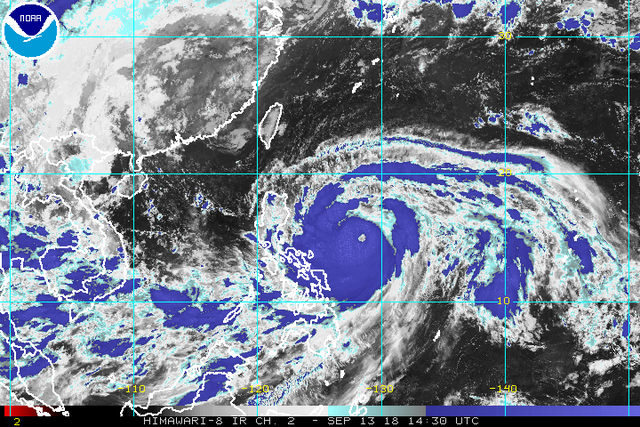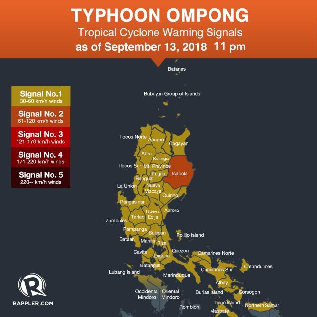
Isabela became the first province to be placed under Signal No. 2 due to Typhoon Ompong (Mangkhut), while nearly the entire Luzon stayed under Signal No. 1 along with Northern Samar on Thursday evening, September 13.
In a bulletin issued 11 pm on Thursday, the Philippine Atmospheric, Geophysical, and Astronomical Services Administration (PAGASA) said Ompong is already 740 kilometers east of Infanta, Quezon or 485 kilometers east northeast of Virac, Catanduanes, moving west at a slightly slower 20 kilometers per hour (km/h) from the previous 25 km/h.
The typhoon continues to have maximum winds of 205 km/h and gustiness of up to 255 km/h. Even if PAGASA does not yet classify Ompong as a super typhoon, it remains to be a powerful tropical cyclone with a huge diameter of 900 kilometers.
Signal No. 2 is now up in Isabela, while Signal No. 1 is raised in:
- Batanes
- Cagayan including Babuyan Group of Islands
- Apayao
- Abra
- Kalinga
- Mountain Province
- Ifugao
- Benguet
- Pangasinan
- La Union
- Ilocos Norte
- Ilocos Sur
- Quirino
- Nueva Vizcaya
- Nueva Ecija
- Bulacan
- Rizal
- Aurora
- Pampanga
- Bataan
- Zambales
- Tarlac
- Metro Manila
- Cavite
- Batangas
- Laguna
- Quezon including Polillo Island
- northern part of Occidental Mindoro
- northern part of Oriental Mindoro
- Masbate
- Marinduque
- Camarines Norte
- Camarines Sur
- Catanduanes
- Albay
- Sorsogon
- Burias and Ticao islands
- Northern Samar

PAGASA warned there may be heavy to intense rain, storm surges in coastal areas, and very strong winds in Cagayan Valley and the Cordillera Administrative Region beginning Friday, September 14, and in Northern Luzon on Saturday, September 15.
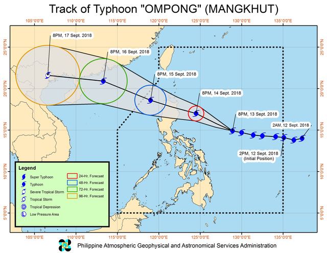
Ompong might make landfall in the Cagayan-Isabela area early Saturday morning.
PAGASA warned that serious floods and landslides are possible, while many trees could get uprooted and homes made of light materials may be damaged.
Fishermen and others with small sea vessels are also advised not to venture out into the seaboards of areas under tropical cyclone warning signals, and in the northern seaboard of Northern Luzon as well as the eastern seaboards of the Visayas and Mindanao.
More than 3,500 passengers were stranded in various ports on Thursday. Several flights were also canceled.
Class suspensions have already been announced for the rest of the week. (READ: #WalangPasok: Class suspensions for September 13, 14, 15)

Forecast track of Typhoon Ompong (Mangkhut) as of September 13, 2018, 11 pm. Image from PAGASA
The typhoon is also enhancing the southwest monsoon or hanging habagat. The enhanced southwest monsoon could trigger moderate to heavy rain in Palawan, the Zamboanga Peninsula, and the Visayas from Friday to Saturday.
Residents of areas affected by the southwest monsoon should be on alert for flash floods and landslides, too.
National government agencies, local government units, the Armed Forces of the Philippines, the Philippine National Police, and the Philippine Coast Guard were placed on alert to respond to the typhoon. (READ: What gov't has done so far to prepare for Typhoon Ompong)
Ompong is the Philippines' 15th tropical cyclone for 2018. The country usually gets an average of 20 tropical cyclones per year.


0 Mga Komento